Mobile access to West Bengal land records and measurement tools
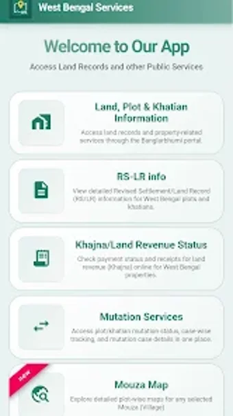
WB Land Plot Khatian Info, from Public Data InfoTech, provides mobile access to West Bengal land records for quick lookup and reference. The app enables search by Khatian or Plot number, shows mutation status and Mouza map imagery, and supplies GPS-based area measurement for on-site checks. It also supports PDF export and local saving of retrieved records. Designed for landowners, buyers, surveyors, and legal professionals who need verified public data on the move.
What practical role does the app play for land professionals?
The app acts as a compact interface to Banglarbhumi-style public datasets, built for mobile retrieval of official land entries. Users navigate District, Block, and Mouza selectors, then supply a Khatian or Plot (Dag) number to pull owner details, classification, LR/RS notations, and mutation status. That search path mirrors field workflows, so teams performing property checks can reach the exact record structure used by land offices.
How does it perform for field surveying and measurement tasks?
Field users gain a set of utilities aimed at on-site validation, including a built-in GPS area measurement tool, a length converter, and a land-division calculator. The app also presents Mouza maps that can be viewed on device, which helps visual correlation between recorded boundaries and GPS traces. These tools support quick cross-checks when surveyors and buyers need an immediate dimensional estimate in the field.
Is the interface and onboarding suitable for non-specialists?
The mobile-optimized interface reduces the navigation complexity often encountered on browser portals, though effective use requires basic familiarity with District, Block, and Mouza nomenclature. Templates or guided workflows are not highlighted, so casual users benefit from a short learning session or reference notes. Saved records for offline review make follow-up research easier for students and legal professionals working away from network coverage.
How reliable is data access and compatibility with official sources?
Data is retrieved live from government servers and the app presents publicly available entries from the official land registry. Because it is an independent, unofficial client, its accuracy matches the source but its availability links to the source systems' uptime. For cross-system exchange, exported PDFs provide a portable copy that teams can archive or share within standard document workflows.
The app suits professionals needing quick mobile reference, with one operational caveat
The app is a practical option for surveyors, legal advocates, and property buyers who need rapid mobile reference to public land records; it serves well for preliminary checks and field notes. Expect dependency on source availability and treat retrieved entries as reference material, not a replacement for formal filings handled through official channels.